

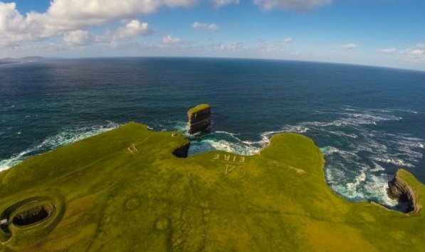
Downpatrick Head
 The impressive and world-celebrated Céide Fields, in Irish Achaidh Chéide - ‘Fields of the Flat-Topped Hill,’ are situated some nineteen kilometers north-east of Killala, at Belderrig, Ballycastle. Representing the oldest enclosed Neolithic field system ever discovered in the Western World, the Céide site is approximately five and a half-millennia old. Originally discovered in the 1930s by a local schoolteacher, Patrick Caulfield, and excavated and developed in the 1980s by his son, Dr. Seamus Caulfield, the site which boasts an award-winning interpretive centre, is still an ongoing archaeological investigation, and the extensive remains of megalithic tombs, stone filed walls and dwellings may be seen, having been perfectly preserved beneath a protective blanket of peat bog. For more information check out www.ceidefields.com
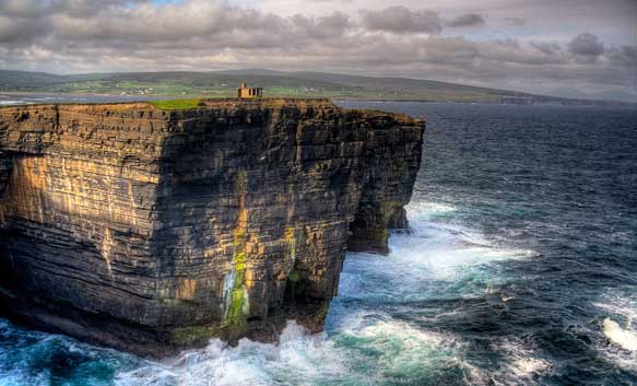
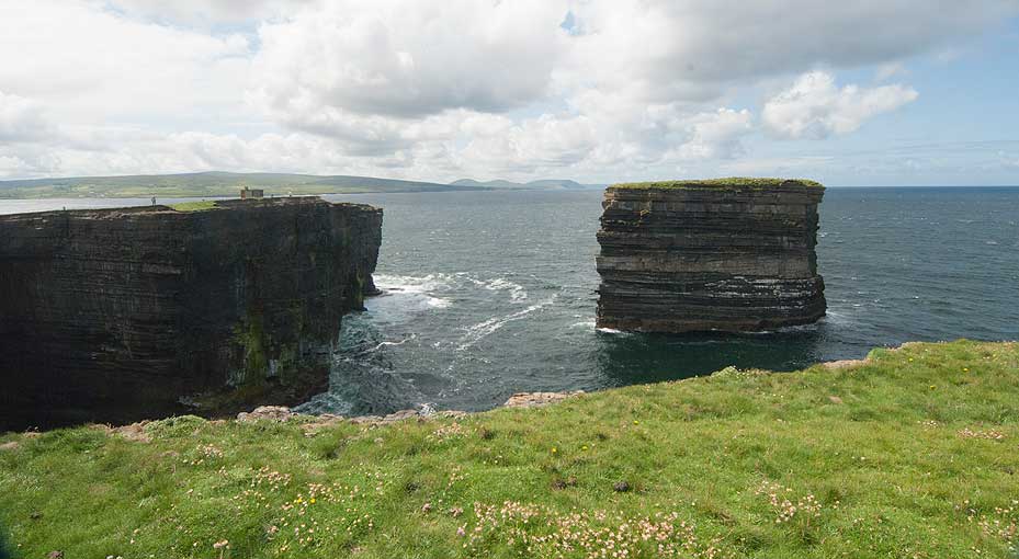
From atop the visitor centre, one can get a wonderful view of this ancient and sacred landscape stretching as it does off down by the majestic Céide cliffs and across the foam to historic Downpatrick Head with its awesome, legend-encrusted blow-holes and the mighty storied sea-pillar of Dún Briste - ‘the Broken Fort.’
“In this class has some right to be enumerated a singular phenomenon which, ten miles below Killala, presents itself. After travelling from Killala about nine miles due west, then for another, you gradually ascend upon a neck of land which stretches into the ocean, narrowing to a point till you arrive at a precipice, three hundred measured feet from bottom to top, upon which the sea is always rough, and dashes in tremendous billows.”
(A Statistical Survey of the County of Mayo, James McParlan, 1802)
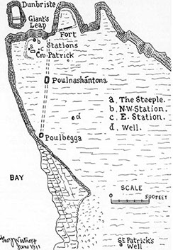
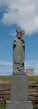
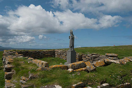
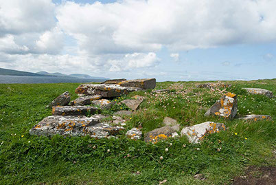
 The headland of Downpatrick, in Irish, Ceann Dhún Pádraig ‘the headland of Patrick’s Fort,’ from its association with our patron saint, boasts several archaeological monuments which range in type from Bronze-Age ring-barrows, early ecclesiastical and Patrician sites, a “Holy Well” dedicated to St. Bridget, the remains of a promontory fort, to the more modern “LOP,” as these Second World War ‘Look Out Posts’ were known: this particular post bore the number 64.The most prominent structure on the headland is the building known as ‘St. Patrick’s Church’ which is said to have been built by the Saint himself and now houses a typically stylized representative statue of him. What follows is a description of the church by Thomas Westropp, in 1912:-
 “Saint Patrick’s Church, in ruins, is sixteen yards long inside and six yards broad. Of the east gable only two or three feet in height remain. Of the north side wall four feet high remain, and of the west gable, are four feet in height to be seen, near which the south side wall is four feet high, and three feet near the doorway, which height remains thence to the east gable. The doorway, which was on the south side wall as is observed, can be ascertained to have been three feet broad. No feature remains which would indicate the antiquity of the building. The walls were built with flat stones taken from a quarry; at a distance there is no appearance of cement; but the interior of the walls contain some apparently of the sandy clay of the headland itself which, from the quantity of it and the manner in which it is laid between the stones, appears to have been used in the building of the church. We may however, reasonably calculate that some of this sandy clay was at various times insinuated by the stormy winds into the openings between the stones, which were so loosely laid.”
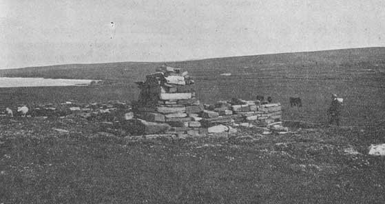
Close by the church and maybe forming part of it there once stood a peculiar structure which a nineteenth century antiquarian described as being “…one of the most curious, the only one of the kind I ever saw attached to a church.” As far as may be ascertained, no-one, be they scholars, folklorists or local historians really know what the purpose of this building was, and while some accounts mention it as being a steeple, and others as Caisleán Phadraig- ‘St. Patrick’s Castle,’ the local lore mentions it as being an altar ‘St. Patrick’s Altar, ’which Patrick or one of his disciples ascended occasionally to pray on and apparently its original form indicated that it was used as such. In 1838 the altar was described in the following manner:-
 “First, there is a square whose side may be said to be ten feet, and height no more than six inches. Over this is a square whose side is about seven feet seven inches, and height twelve inches. Over this second square is a third whose side is six feet ten inches, and height six or seven inches: and over this third one is a fourth whose side is five feet, and height twelve inches; over which fourth one is a fifth whose side is four feet three inches, and height two feet; on this fifth one is placed a sixth, so as to have its corners fixed on the middle of the sides of this fifth square, thus forming four triangles of equal size with one another, two sides of every one of which is each eighteen inches; whilst the third, made by the side of this sixth square, is two feet, which is the length of the side of the square as well as its height. On this last square is placed what is popularly called a ‘Coping’- a number of stones rudely placed together and inclining to come to a point-whose height is about fourteen inches. The whole height may be said to be seven and a half feet or eight feet. In the four lower squares are observable a few specks of cement among the stones; in the fifth and sixth a considerable quantity is observable. There is some laid under the ‘Coping’ on the square, but none in itself. This cement consists of lime and sand mortar.”
‘St Patrick’s Altar’ is again referenced in the following piece pertaining to Dún Briste: “East and North West of the church several small piles of stones (now scattered) were once visible; these piles may have been Christian ritual monuments or ‘Station Stones.’ Stations or Patrons were held here annually on the last Sunday in July, Garland Sunday, and also on Good Friday. Garland Sunday was known in pagan times as Crom Dubh’s Day.”
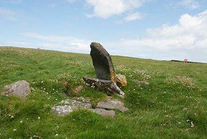 It is also claimed in the local lore that several stone crosses associated with the ‘Stations’ once stood here, as did a curious stone which was known alternatively as the “Lamb’s Head Stone”, or the “Anvil Stone. The lore further tells that the stone was a very regular oblong block with a raised panel on top and it was on this stone that St. Patrick shod his donkey when he first came to this district. The nineteenth century author Cesar Otway, who visited Downpatrick, tells how an old woman used to show the pilgrims how to perform the rituals ‘the penances and rounds’ in honour of St. Patrick, and further describes the idlers, fiddlers, and dancers, mixed with the serious devotees, the yellow and red clothing of the women, and the hunting of a hare surprised in its form by then pilgrims.
Of the growling blow-holes on the headland, Poll na Seantuinne/ Poll na Sean Toinne-‘the Hole of the Old Wave’ is by far the largest, most impressive and the one most associated with the history and folklore of the place-the others are known in the region as Poille Beaga-‘Small Holes.’
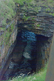 Formed by countless years of marine erosion, and while there are many legends extant which give this chasm more fantastic origins, it is the true story of the murder of 23 rebel fugitives from the nearby villages of Knockbaun and Killeen in 1798, by members of the notorious Fraser’s Fencibles, a British Army Regiment, which is remembered by the local people and still spoken of today. One synopsised version tells that using súgán ropes or ladders ( fashioned from straw) provided by sympathetic neighbours, the fugitives all of whom were fleeing the slaughter then taking place in Killala, lowered themselves into the hole hoping to find refuge. An alternative version tells that the rebels entered the chasm by the coast at low-tide. Unfortunately for the fugitives, the “Frasers” happened upon the scene and opened a murderous fire on the men trapped far below. It is told that after about thirty minutes of firing, the soldiers lowered their weapons and stood around gazing down on those unfortunates “lucky” enough to have escaped the fusillade, as they cowered in terror, for with the passing of each terrible moment, the merciless sea rose higher and higher!


Lorem ipsum dolor sit amet.2
Lorem ipsum dolor sit amet.3
Lorem ipsum dolor sit amet.4
Lorem ipsum dolor sit amet.5
Lorem ipsum dolor sit amet.6
Lorem ipsum dolor sit amet.7
Lorem ipsum dolor sit amet.8
Lorem ipsum dolor sit amet.9
Lorem ipsum dolor sit amet.10
Lorem ipsum dolor sit amet.11
Lorem ipsum dolor sit amet.12
Lorem ipsum dolor sit amet.13
Lorem ipsum dolor sit amet.14
Lorem ipsum dolor sit amet.14
<
>
13 - 14
View these photos in a gallery